Mobility in Greater Cairo Region: What Work Trips Tell Us About Everyday Commutes
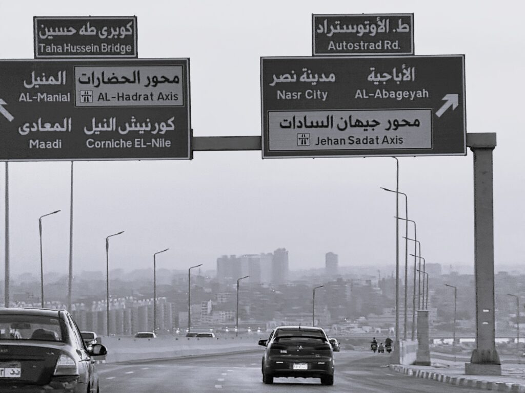
Photograph on the National Museum of Egyptian Civilization (NMEC) bridge. Photo credits: Yasmine Sabek
Across the years, Transport for Cairo (TfC) has conducted extensive origin–destination (OD) surveys across the Greater Cairo Region (GCR). Between 2021 and 2024, more than 22,000 trips were surveyed, capturing how people move across Cairo, Giza, and El Qaliobia, the three governorates that make up the GCR.
Out of these, around 5,600 trips were for work purpose, travelling to or back from work, offering a valuable lens into commuting patterns in GCR.
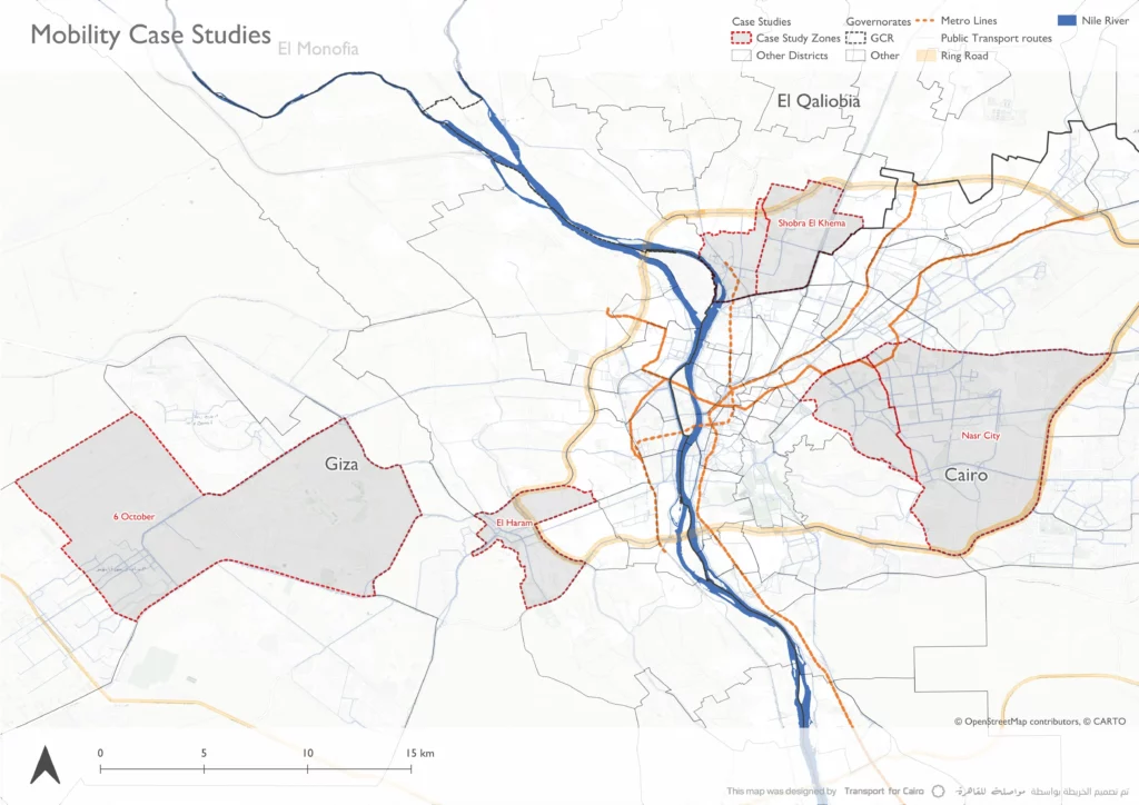
This blog post looks exclusively at work-purpose trips, taking palace between 6 am and 11:59 pm, analysing them both at governorate and districts levels, highlighting 3 case studies from 4 different districts, showing how the urban fabric and public transport affect the commuting patterns within the GCR.
What are Origin-Destination (OD) Surveys?
travellers in the streets Origin-Destination (OD) surveys are a type of passenger survey where field researchers ask travellers in the streets about their current trip – where it started, where it’s going, which mode or modes are used, and why it’s being made, alongside some basic demographic information.
OD surveys and household travel surveys are widely used by cities and transport planners to understand commuting, access to jobs, and how different areas of a city are connected. They complement traffic counts to understand both people’s travel behaviour and vehicle flows.
The collected data is used in transport analysis and modelling to assess demand, test future scenarios, and support planning decisions.
Used terms:
Household travel surveys: refer to interviews with members of sampled households reporting all the trips made on a given day, including when and where each trip started and ended, the mode or modes used, the purpose of the trip, other trip details, alongside household demographic details. Traffic Counts: refer to the recording of the number of vehicles, and sometimes pedestrians, that pass a specific point on a road during a time interval.
GCR in numbers
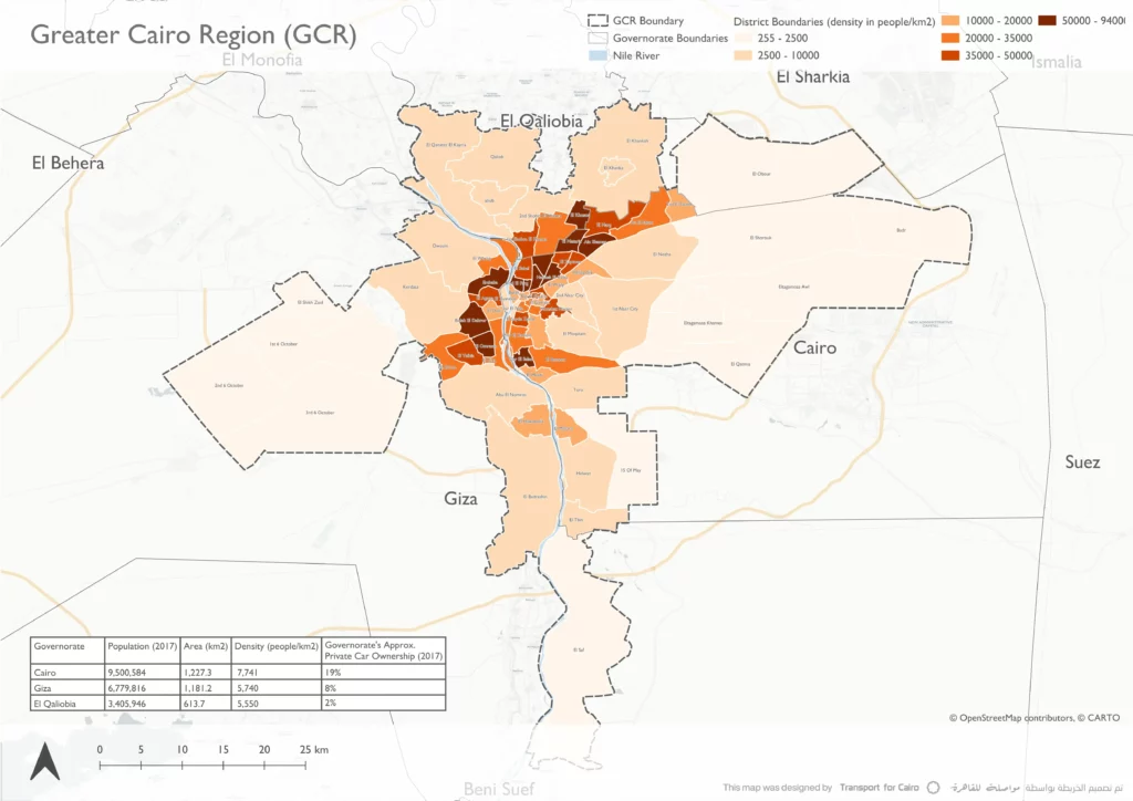
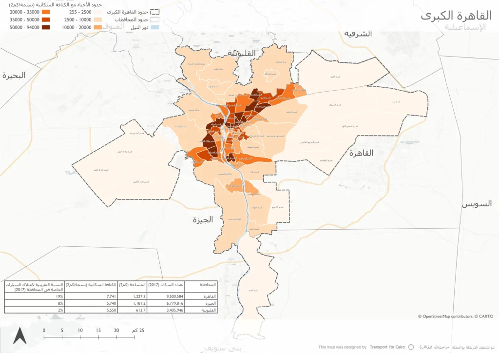
Greater Cairo Region (GCR) is Egypt’s largest metropolitan area and one of the most populated urban regions in Africa. It is home to over 20 million residents living in multiple districts with different characteristics across 3 governorates: Cairo, Giza, and Qaliobia.
An analysis of more than 5,600 surveyed work trips shows that, at the governorate level, commuting is concentrated largely within Cairo and Giza, alongside notable inter-governorate flows that reflect strong links across the GCR.
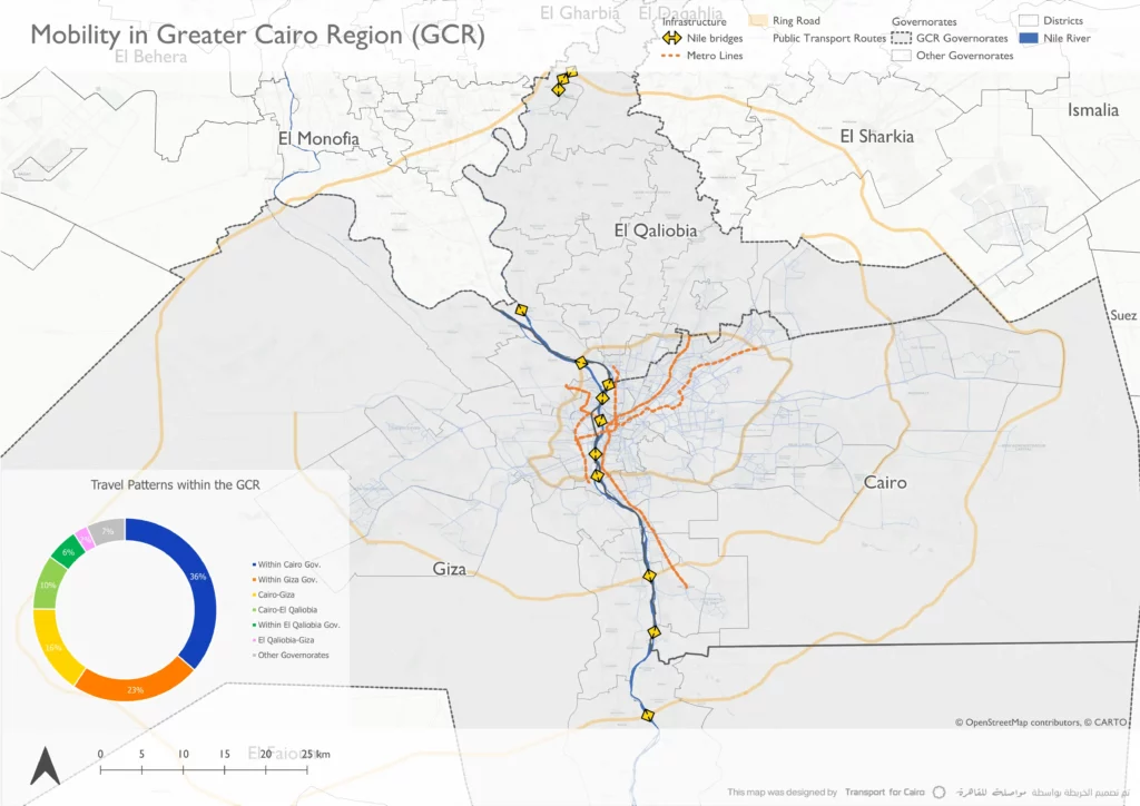
The majority of the surveyed work trips (65%) take place within the same governorate, with Cairo accounting for approximately 36% and Giza for around 23%. Inter-governorate trips are most prominent between Cairo and Giza (about 16%), followed by trips between Cairo and El Qaliobia (around 10%).
The data shows that a large share of work-purpose trips in GCR remain within the same governorate’s boundaries, while inter-governorate trips tend to rely on major corridors and Nile bridges that connect the region.
These commuting patterns are supported by regional infrastructure such as major road corridors, Nile crossings, and high-capacity public transport systems, including the Cairo Metro, alongside extensive formal and popular public transport networks.
Modal Share Across Governorates
Looking at modal share across the three most common governorate-level commute patterns highlights both shared characteristics and clear differences in how people travel to work.
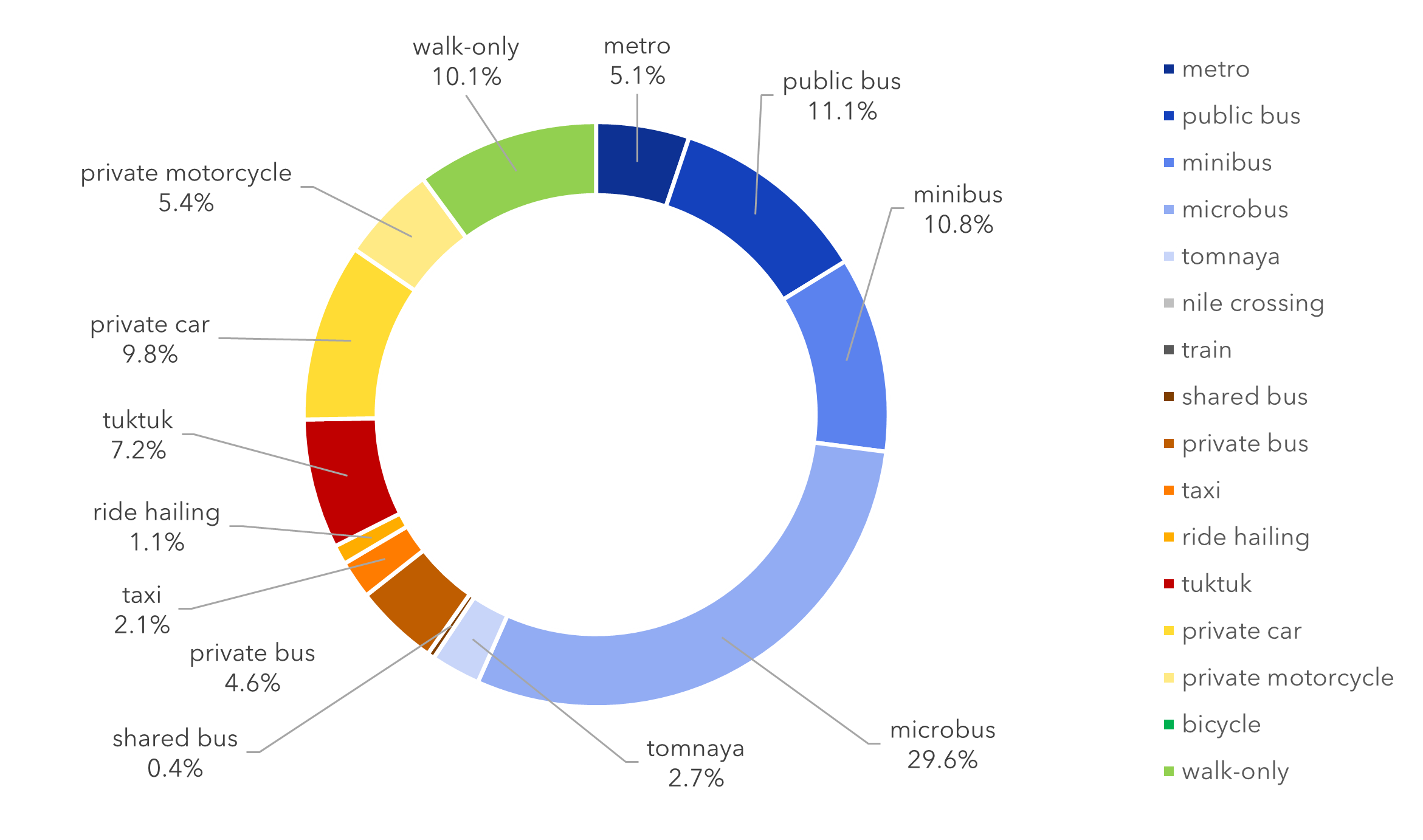
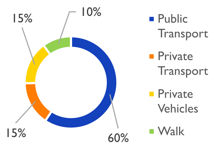
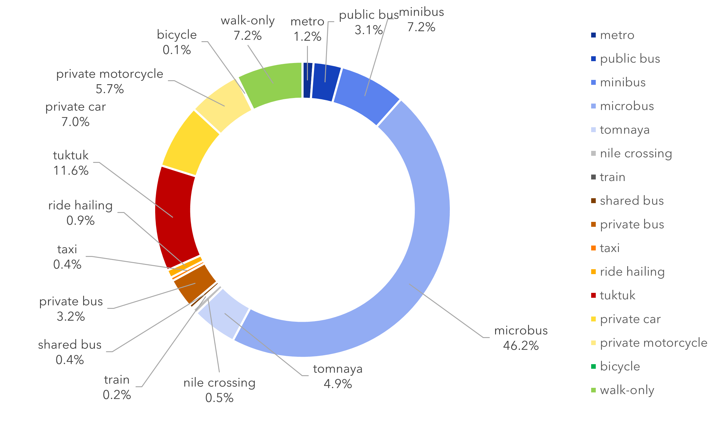
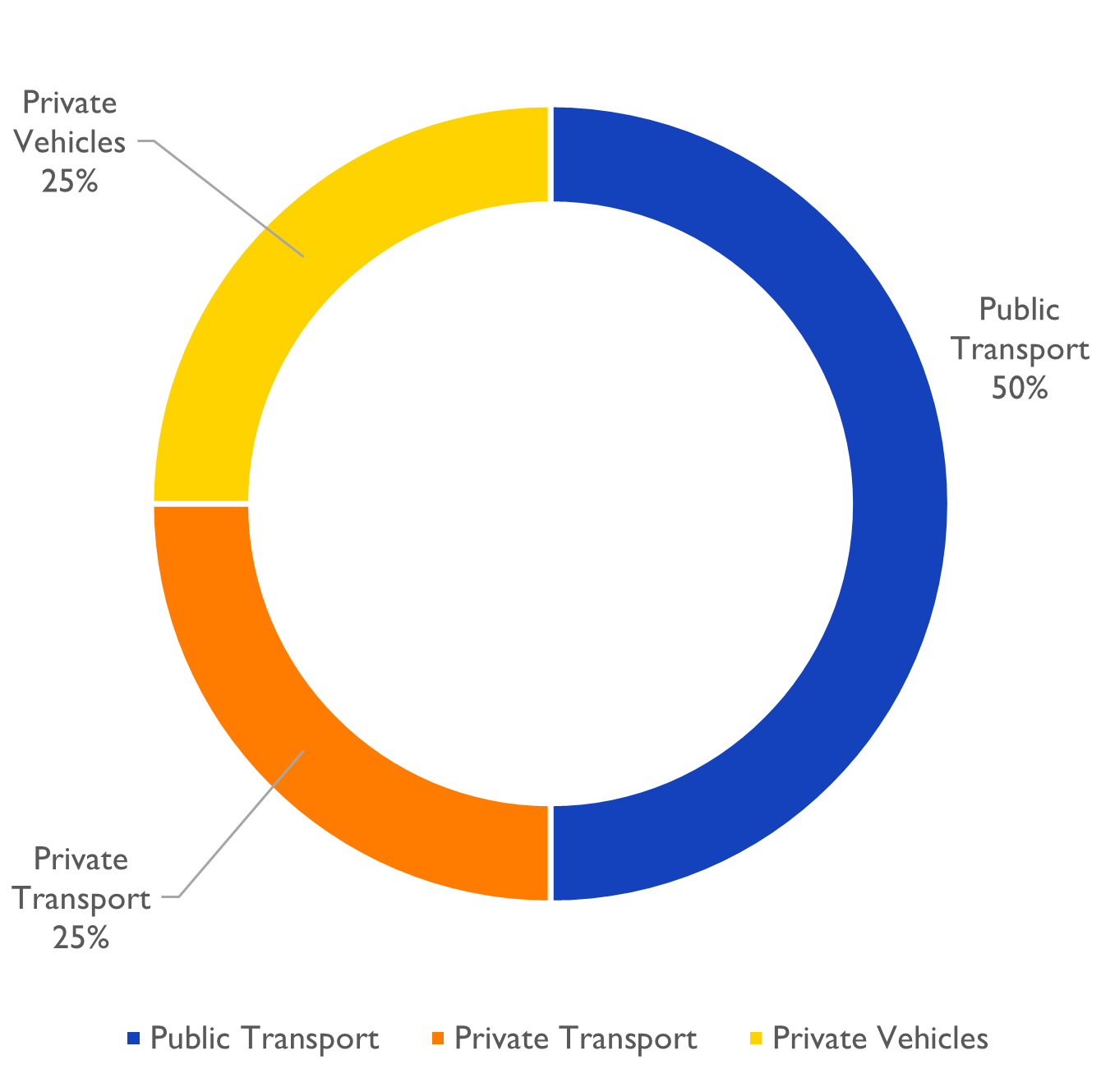
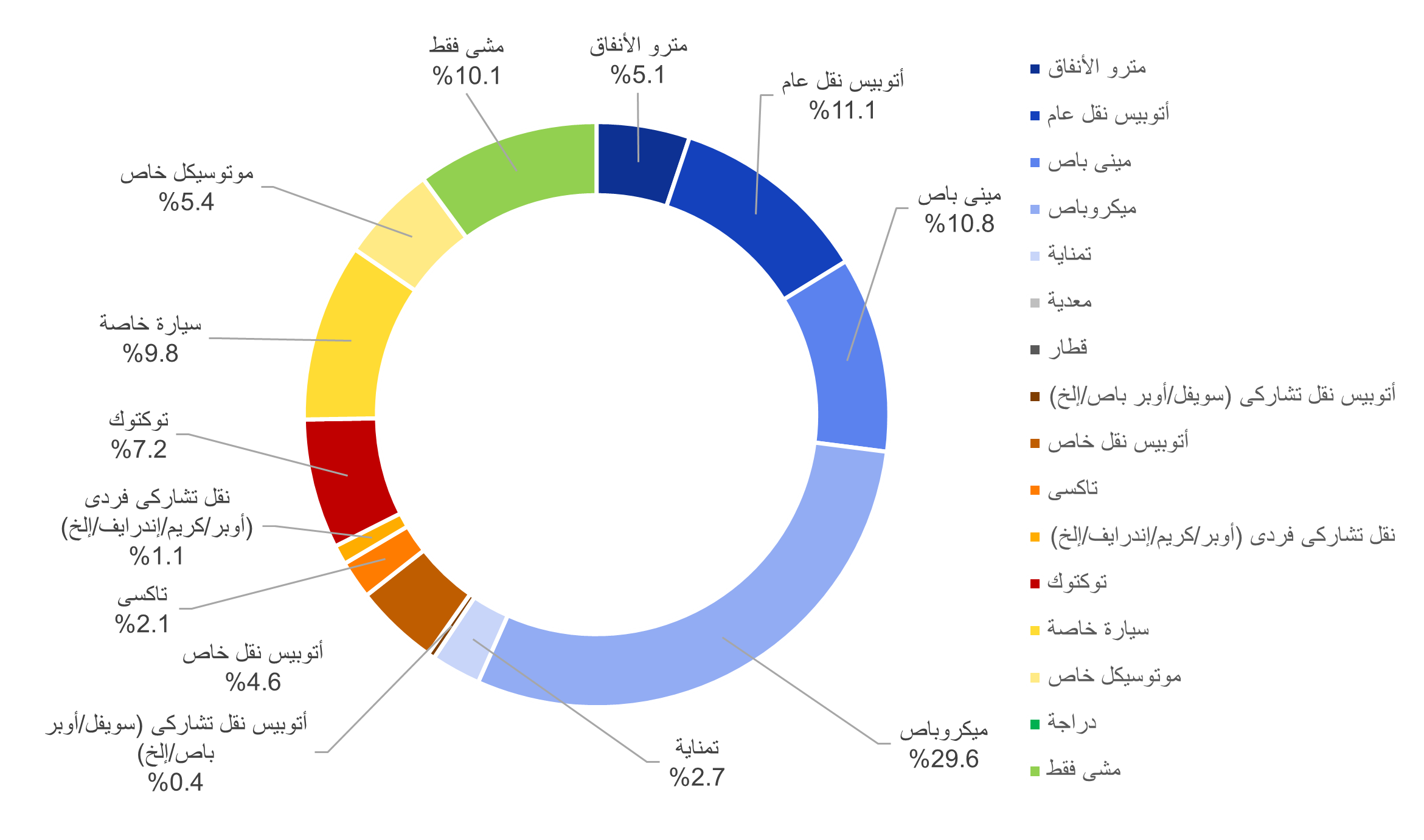
Across all three patterns, microbuses emerge as the dominant mode of work travel, accounting for at least 30% of trips. Private car use remains limited, making up less than 10% of surveyed work commutes.
Commutes within Cairo Governorate
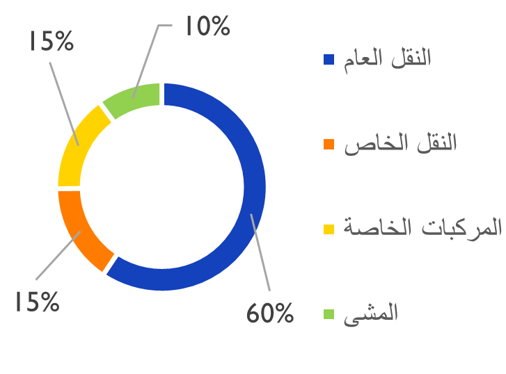
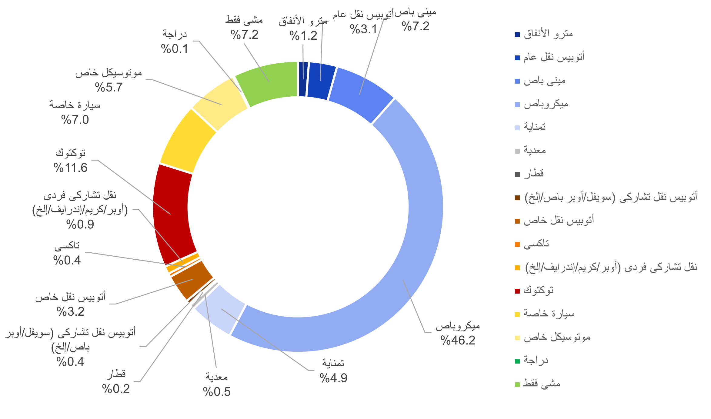
Modal share within Cairo governorate
Modal share within Cairo governorate (categorized)
Within Cairo Governorate, work commutes are dominated by microbuses, followed by public buses and minibuses, with walk-only trips, and private cars coming in next.
Commutes within Giza Governorate
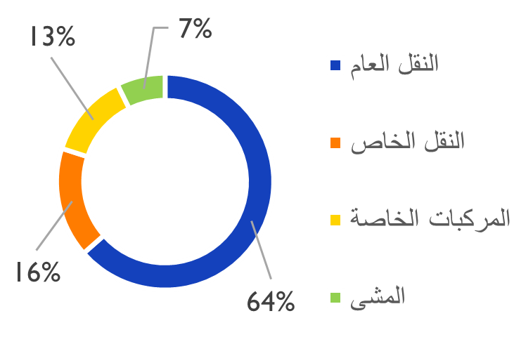
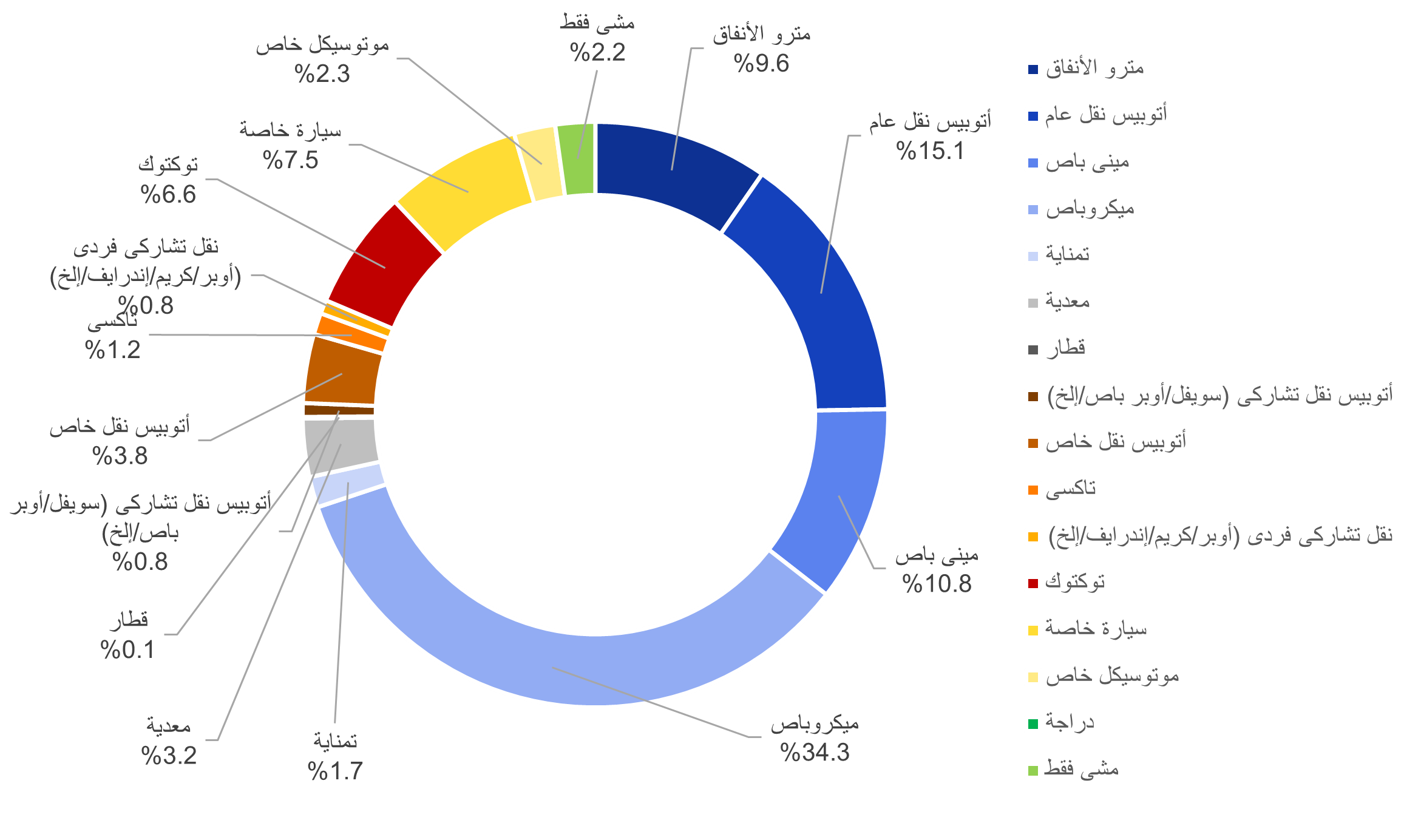
Modal share within Giza governorate
Modal share within Giza governorate (categorized)
Within Giza Governorate, microbuses are even more prominent in work commutes, while tuktuks account for a noticeable share, reflecting the role of smaller vehicles in local access.
Commutes between Cairo and Giza Governorate
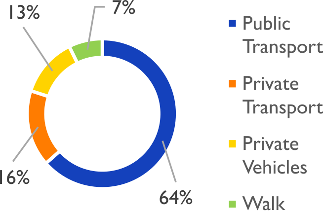
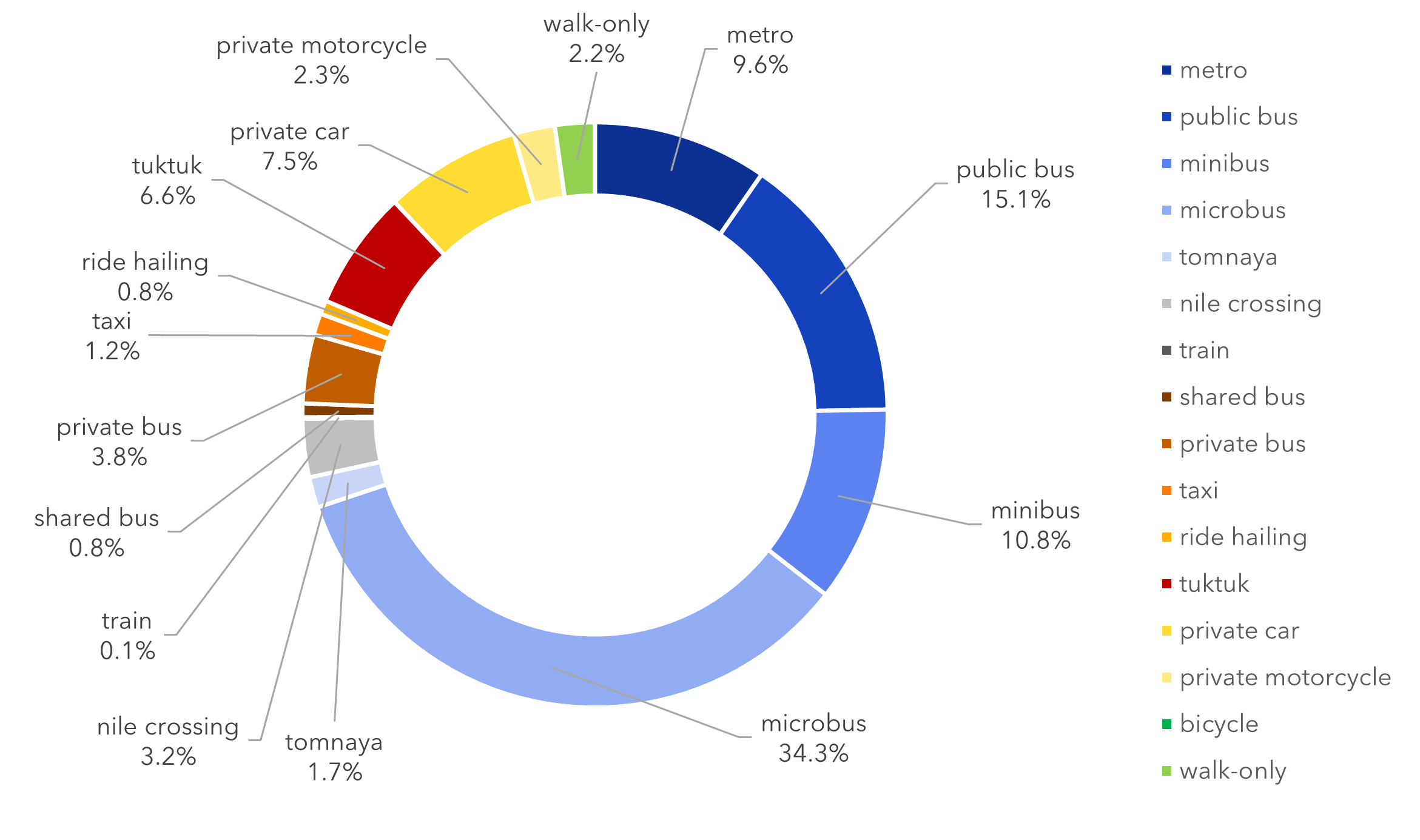
Modal share between Cairo and Giza governorate
Modal share Between Cairo and Giza governorates (categorized)
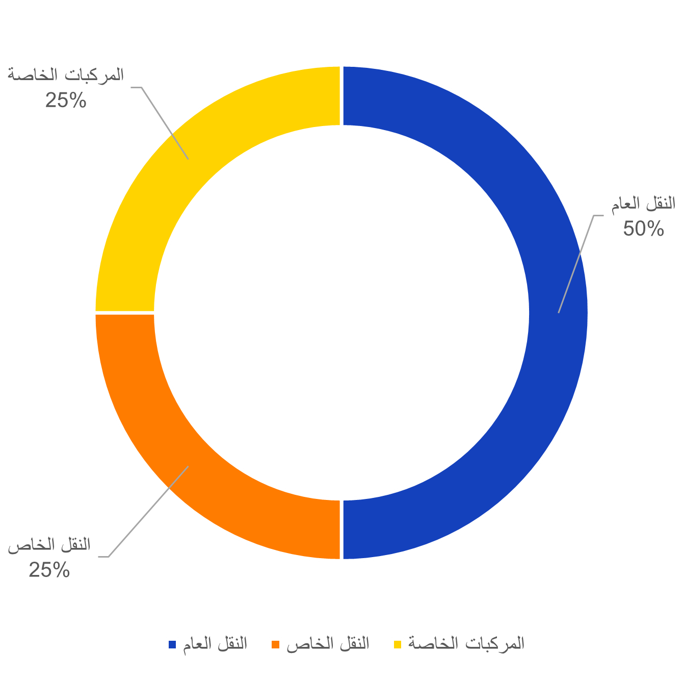
For commutes between Cairo and Giza, microbuses remain dominant, but higher-capacity modes such as public buses, minibuses and the metro play a more visible role than in internal trips within governorates.
Used terms:
Public Transport includes: metro, public bus, minibus, microbus (14-seater), tomnaya (8-seater), Nile crossing, and intercity train
Private Transport includes: shared bus (bus-hailing services), private bus (e.g. company buses and school buses), taxi, ride hailing, and tuktuk (three-wheelers)
Private Vehicles are personal/private cars and motorcycles
Walk is for walk-only commutes
Looking Closer: Work Commutes Within and Between Districts
Now, let’s take a look at two examples of districts that have most of the surveyed work-trips taking place within themselves, and an OD pair between two districts where a significant number of the surveyed work-trips moved between them. 1- Commutes within Nasr City, Cairo Governorate 2- Commutes within Shobra El Khema, El Qaliobia Governorate 3- Commutes between Haram and 6th of October City, Giza Governorate
1. Commutes within Shobra El Khema, El Qaliobia Governorate
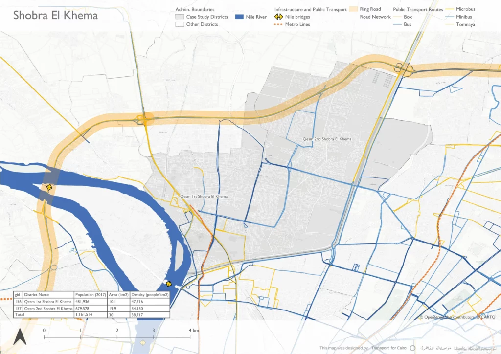
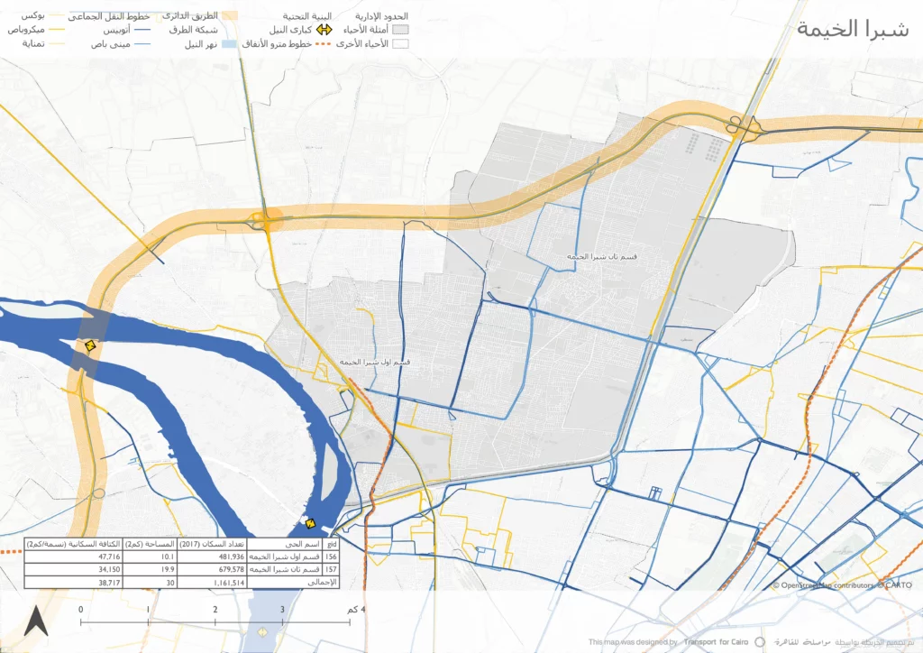
Our first case-study is in Shobra El Khema. It is El Qaliobia governorate’s largest city and Egypt’s fourth-largest city. It is divided into two districts: Qesm 1st Shobra El Khema and Qesm 2nd Shobra El Khema, and since there’s no visible division between the two administrative zones, we will deal with both as one area in this article.
Once a quiet agricultural village, Shobra El Khema underwent a massive 20th-century transformation into a specialized hub for the textile, glass, and chemical industries, which led to a population boom and a dense urban expansion on agricultural land with both planned and spontaneous settlements.
Shobra El Khema map
2. Commutes within Nasr City, Cairo Governorate
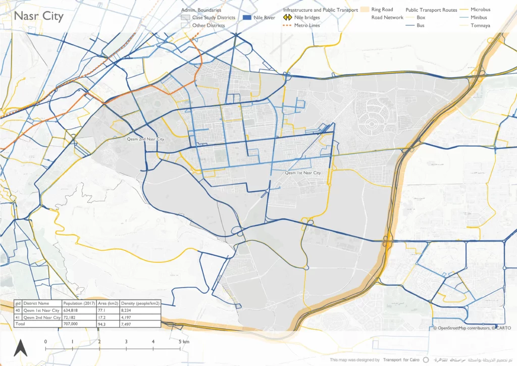
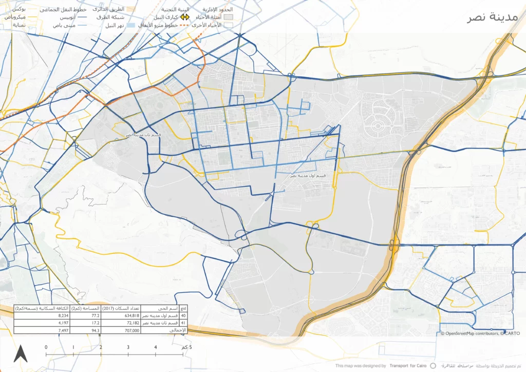
Our second case study is in Nasr City, a city planned in the 1960s on vacant desert land on the east of Cairo’s city center, with an orthogonal grid for roads, residential areas, service centres, and green spaces. Throughout the years, its land-use changed to have more mixed-use specially across main roads, and its density increased from what was originally planned. It is divided into two administrative zones: Qesm 1st Nasr City and Qesm 2nd Nasr City, which we will consider as one zone in this article.
Nasr City map
3. Commutes between El Haram District & 6th of October City, Giza Governorate
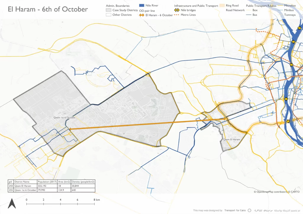
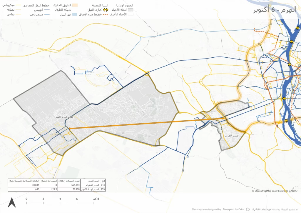
Our third and last case study is for a significant long-distance OD pair between two distrticts: El Haram, a high-density older residential district next to the Pyramids of Giza, and Qesm 1st 6th of October, a district in 6th of October City, a low-density new urban development from the late 1900s located around 32 km to the west of the city center. This example illustrates a common work-residence relationship between older, denser residential districts and expanding new cities with lower densities that provide new job opportunities..
El Haram & 6th of October map
Different Districts – Different Urban Fabric
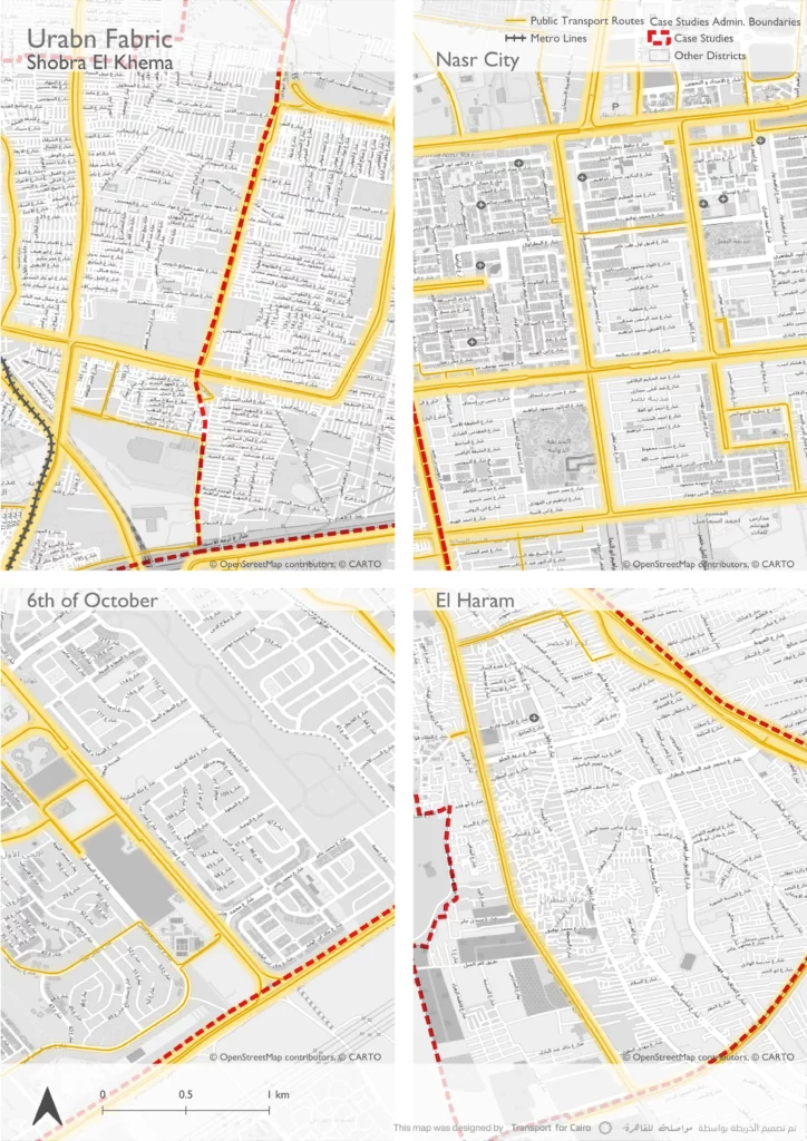
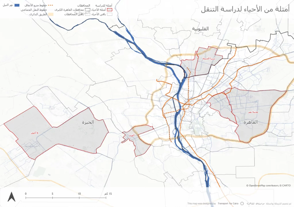
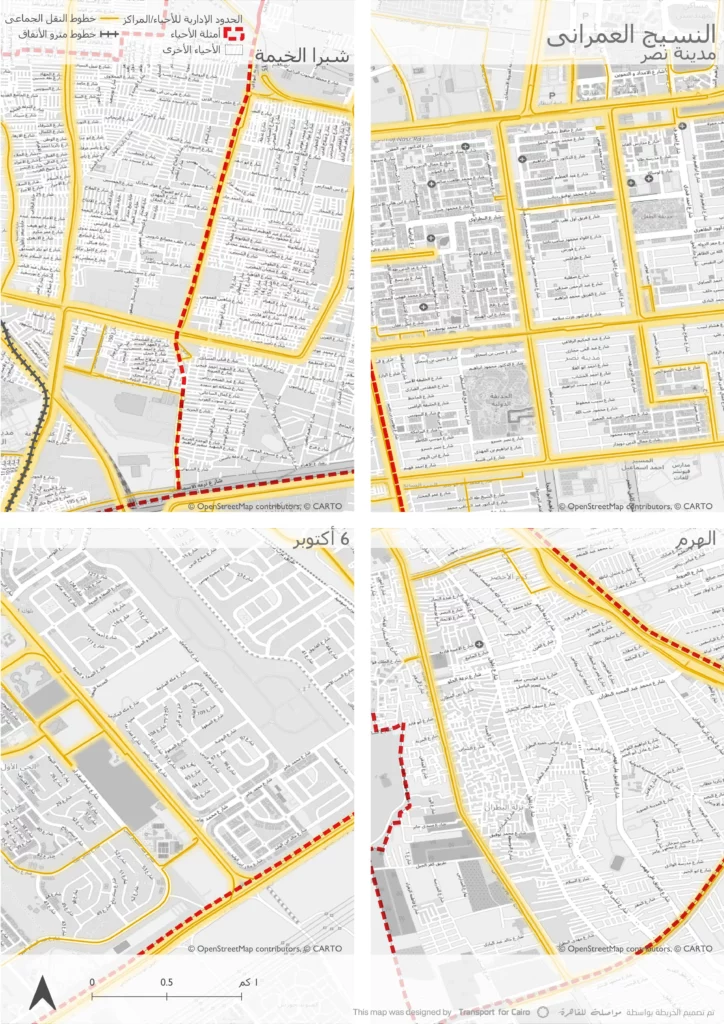
Zooming in on the four case study districts, the following maps show the urban fabric and the public transport routes within the districts. We use the same map scale to allow for comparison between the different urban scales, road networks, and access to PT.
Older districts like Shobra El Khema and El Haram, that usually underwent self-built densification, sometimes on previously agricultural land, show smaller scale plots with higher densities and narrow inner roads, while newer urban developments like Nasr City and 6th of October City follow different urban planning systems with larger-scale blocks, a hierarchy of road types, and dedicated land uses.
We can also notice how the urban fabric affects mobility and access to PT: In Nasr City for example, roads wide enough to accommodate different PT vehicles and proper sidewalks, combined with higher densities, support having a wide range of PT modes and routes.
In contrast, districts with predominantly narrow inner streets, such as in Shobra El Khema and El Haram, support walking but tend to concentrate PT on main roads and rely more on smaller vehicles, like tuktuks (three-wheelers), for first- and last-mile travel.
New urban communities on the other hand, like 6th of October City, may not have enough PT coverage despite their planned road infrastructure due to their low densities.
Urban fabric and PT routes for the case study districts
What the numbers say
Looking across the three case studies from the four districts, the numbers highlight clear differences in how people commute to work depending on distance, density, and urban form. While public transport plays a central role in all cases, the balance between walking, popular transport , private transport, and private vehicles shifts noticeably from one context to another.
Shobra El Khema
Nasr City
El Haram – 6th of October
Population (2017)
1,161,514
707,000
555,192
79,990
Area
30 km2
94.3 km2
18 km2
124.9 km2
Density
38,717 people/km2
7,497 people/km2
30,844 people/km2
640 people/km2
Modal Share in work trips
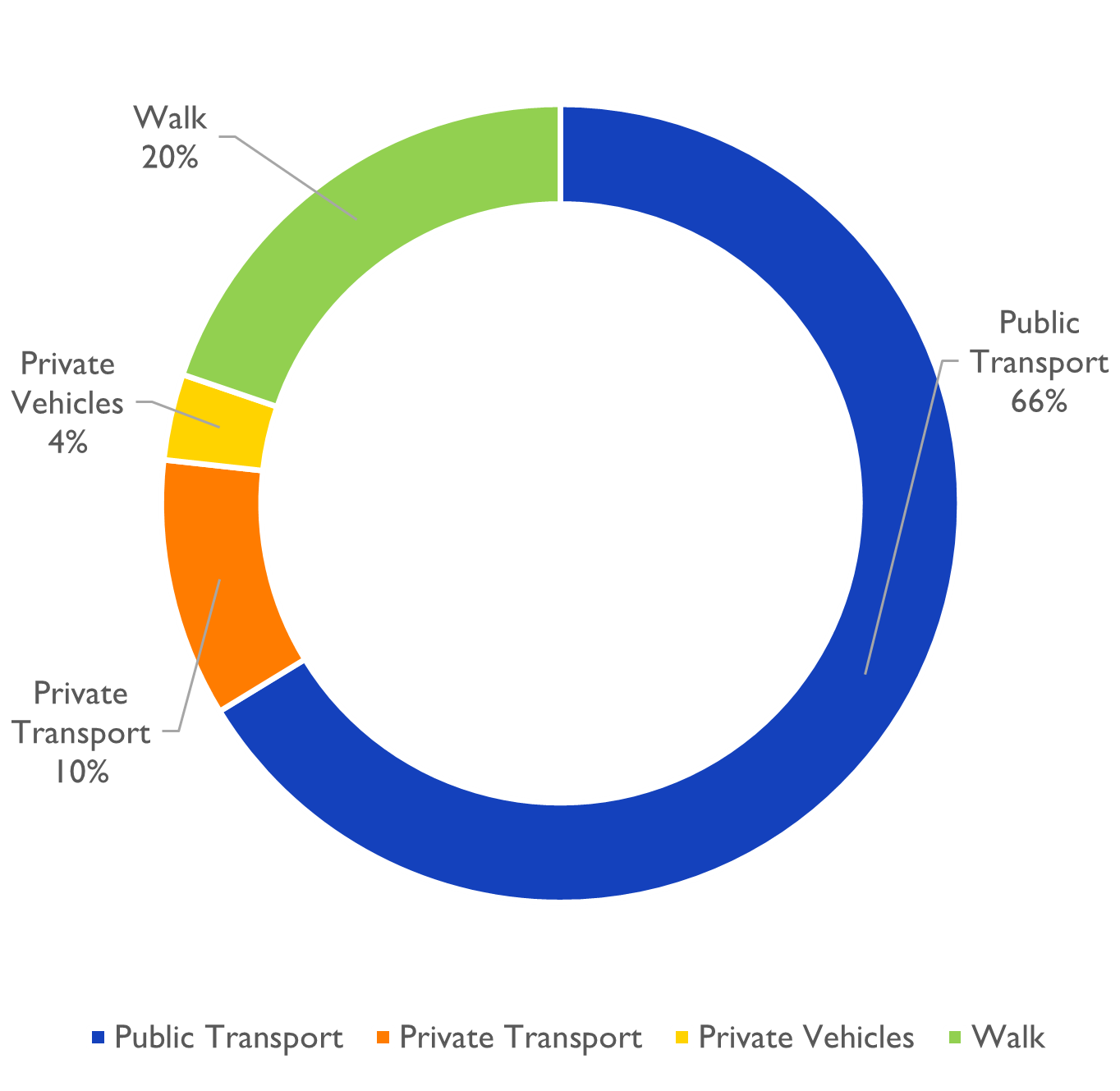
modal share in work commutes within Shobra El Khema
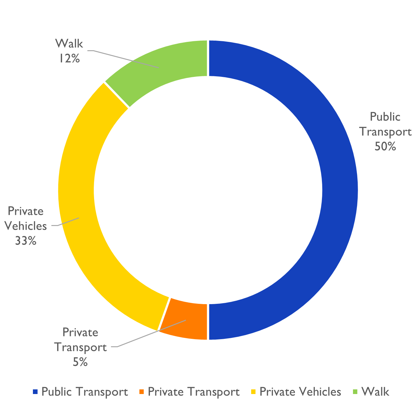
Modal share in work commutes within Nasr City
Modal share in work commutes between El Haram and 6th of October
Shobra El Khema
Population (2017)
1,161,514
Area
30 km2
Density
38,717 people/km2
Modal Share in work trips
modal share in work commutes within Shobra El Khema
Nasr City
Population (2017)
707,000
Area
94.3 km2
Density
7,497 people/km2
Modal Share in work trips
Modal share in work commutes within Nasr City
El Haram
Population (2017)
555,192
Area
18 km2
Density
30,844 people/km2
6th of October
Population (2017)
79,990
Area
124.9 km2
Density
640 people/km2
Modal Share in work trips between El Haram & 6th of October
Modal share in work commutes between El Haram and 6th of October
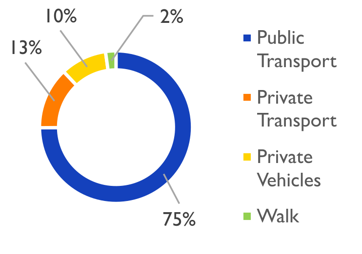
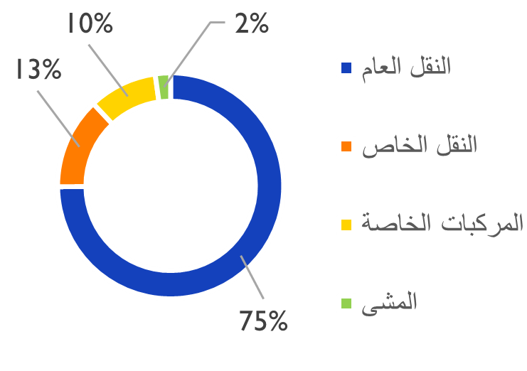
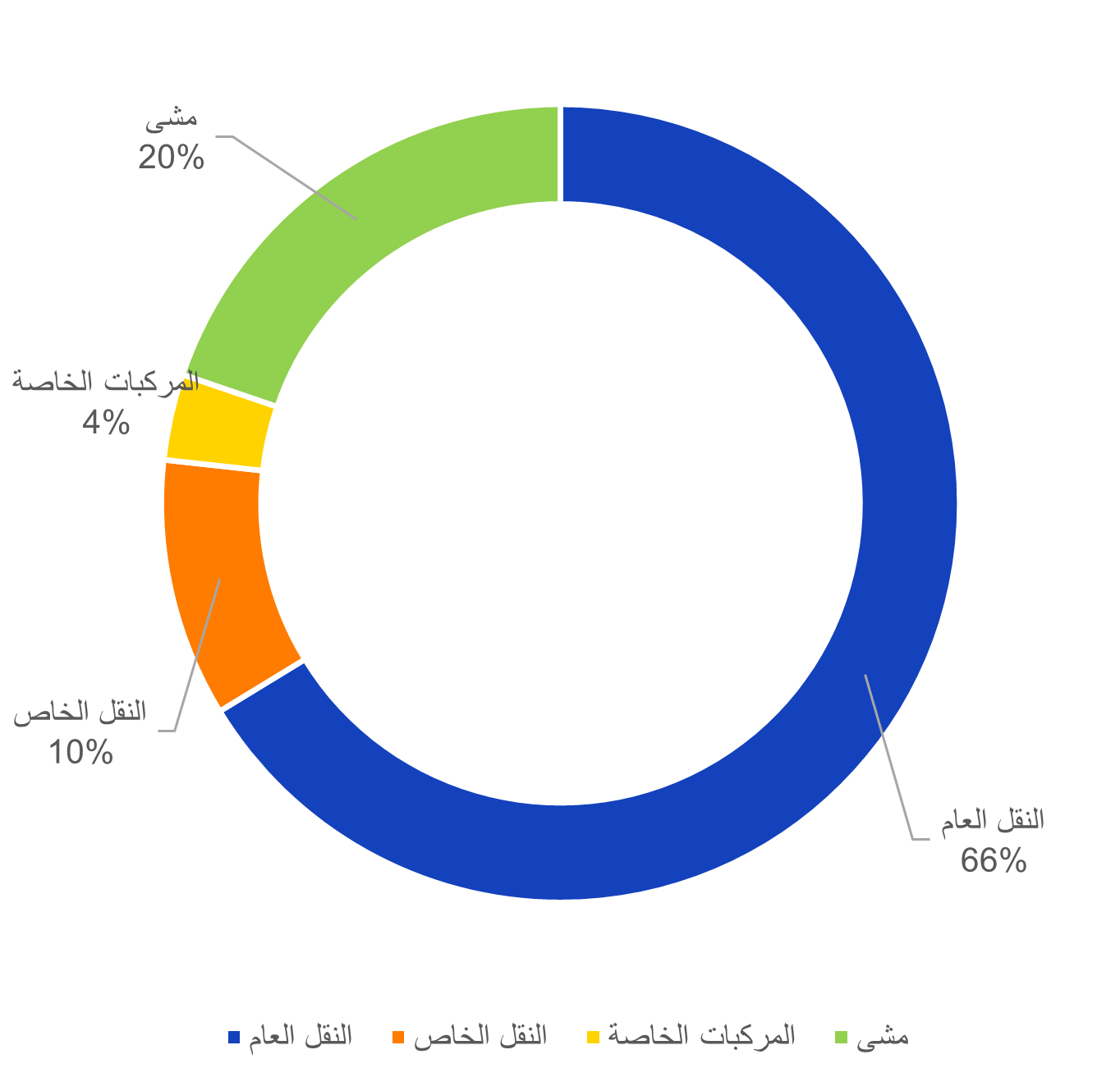
In Shobra El Khema, the data shows a highly localised commuting pattern with an average length of 2km. Around two thirds of the surveyed work trips are made using public transport, and around one fifth are walk-only trips. This reflects both the very high density of the area and the short distances between residential areas, services, and workplaces. Smaller vehicles, particularly tuktuks, appear to play an important role in providing access within narrow inner streets and connecting them to main public transport corridors.
In Nasr City, commuting patterns are more mixed and have average lengths of 3km. Around half of the surveyed work trips rely on public transport, while a larger share of roughly one third is made using private vehicles, a percentage higher than that of Shobra El Khema. This reflects a district with moderate-to-high density, longer average trip distances, and a road network that can accommodate a wider range of transport modes. Walking still plays a role in daily commutes, but less prominently than in denser districts like Shobra El Khema.
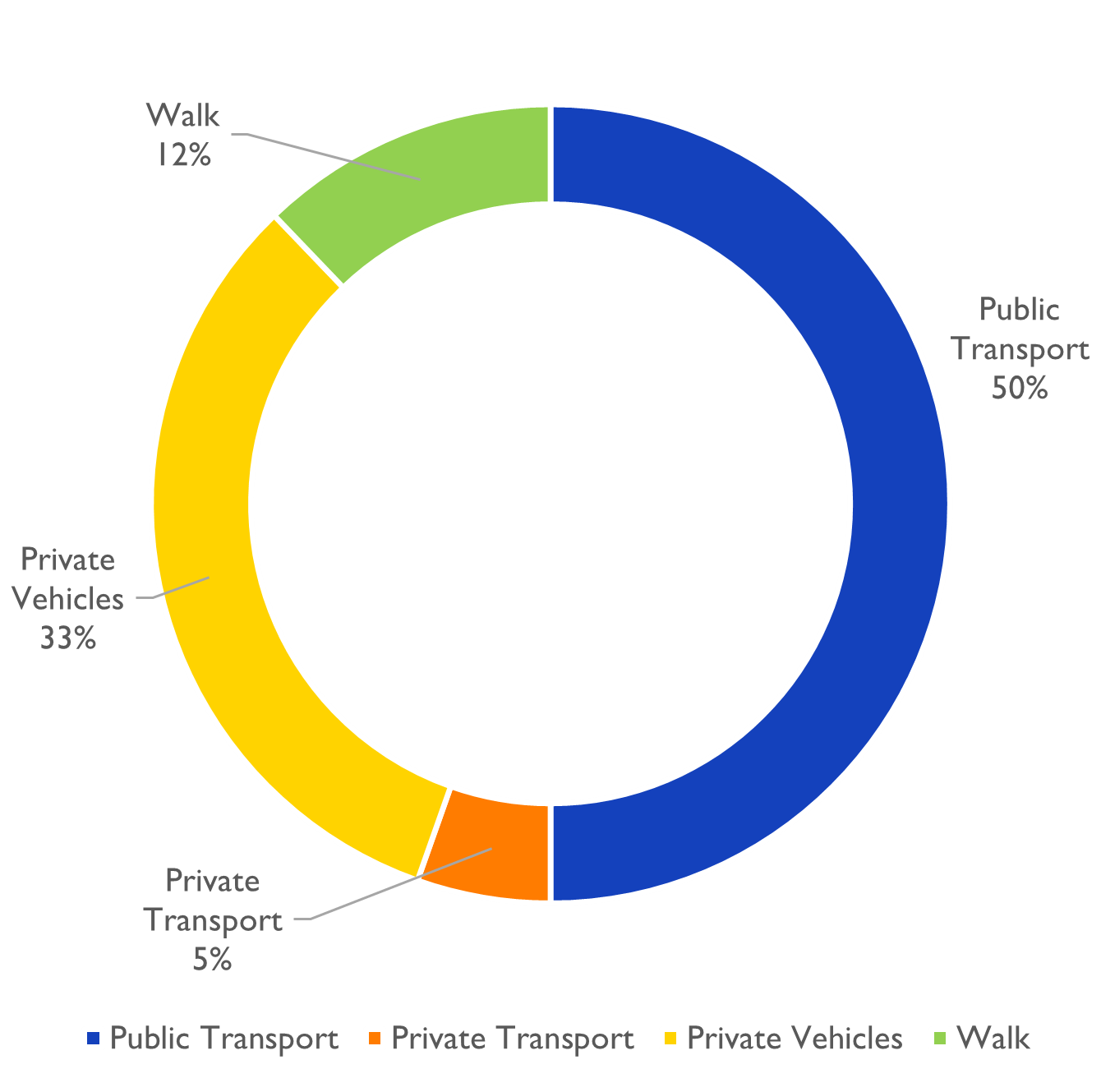
For the long-distance OD pair between El Haram and Qesm 1st 6th of October, public transport remains significant, accounting for around half of surveyed work trips, primarily through microbuses. However, private vehicles and private transport services represent a much larger share than in the other two case studies, reflecting both the distance travelled, the lower density, and the possibly limited public transport coverage of the destination area.
Conclusion
Reflecting on these finds, these OD patterns show that public transport is used in at least half of work commutes across the different urban contexts in the GCR. Popular transport, especially microbuses, plays an important role in connecting residential areas to jobs, regardless of trip length.
At the same time, the modal split between walking, popular transport, and private vehicles varies with density and trip distance. Dense districts with short trip lengths support higher levels of walking and local public transport use, while longer-distance commutes and lower-density urban environments are associated with an increased reliance on private vehicles and private transport services.
The big picture
Looking at work-related trips across the Greater Cairo Region, both at the metropolitan and district-level scales, shows that commuting patterns are not random, but shaped by the urban form, land-use, road networks, public transport availability and accessibility, alongside the spatial distribution of jobs and housing.
The analysis highlights the importance of looking at mobility at multiple scales. Regional infrastructure and mass public transport systems play a key role in supporting longer-distance commutes across governorates, while local street networks, micromobility, urban density, and land-use mix strongly influence shorter, internal trips within districts and neighbourhoods.
The case studies also show that high density and mixed land use in older districts should not be viewed only as challenges because they can, when supported by appropriate public transport services and safe conditions for walking, lay a strong foundation for sustainable mobility. At the same time, newer low-density urban developments can face different mobility constraints, particularly in achieving reliable public transport coverage without sufficient demand.
In the end, public transport, the formal and the popular, remains the backbone of everyday commuting in the GCR. Microbuses in particular play a central role in connecting residential areas to jobs, regardless of trip length. Understanding these patterns requires continued investment in data collection and analysis using different surveys and tools to inform future transport projects and to improve existing ones.
Interested in data? Check the Origin-Destination surveys dataset used in this article here.
Disclaimer
This article is based on Transport for Cairo’s published dataset for Origin-Destination (OD) surveys conducted between 2021 and 2024 in Greater Cairo Region. Origin and destination locations were reported by survey respondents and geocoded accordingly. All attributes reflect respondent-provided information, subject to typical survey reporting accuracy.
The public transport routes mentioned, mapped, and visualized are based on Transport for Cairo’s published datasets and GTFS. Newer and/or intra-neighbourhood PT routes may be unaccounted for.
Population values and number of private cars are based on the 2017 census data from CAPMAS. District areas are calculated from GIS data. Private car ownership per governorate is calculated as (total governorate population) / (governorate’s number of licensed private cars).
Some calculated values and percentages are approximated for simplification.
:التنقل فى القاهرة الكبرى ماذا تخبرنا رحلات العمل اليومية؟
صورة من أعلى كوبرى المتحف القومى للحضارة المصرية. تصوير ياسمين سابق
على مدار السنوات، نفذت شركة مواصلة للقاهرة عددًا كبيرًا من استبيانات البداية–الوجهة فى إقليم القاهرة الكبرى. وخلال الفترة من 2021 إلى 2024، جمعت بيانات لأكثر من 22 ألف رحلة، توضح كيف يتحرك الناس يوميًا فى محافظات القاهرة والجيزة والقليوبية المكوِّنة للقاهرة الكبرى
من بين هذه الرحلات، كانت نحو 5600 رحلة بغرض الذهاب أو العودة من العمل، ما يوفر مدخلًا مهما لفهم أنماط التنقل اليومى داخل الإقليم.
تركز هذه التدوينة على رحلات العمل المرصودة بين السادسة صباحًا ومنتصف الليل، مع تحليلها على مستويين: مستوى المحافظات ومستوى الأقسام والأحياء، من خلال ثلاث دراسات حالة تغطى أربعة أقسام مختلفة لفهم كيف يؤثر النسيج العمرانى وشبكات النقل العام على أنماط التنقل داخل إقليم القاهرة الكبرى.
ما هى استبيانات البداية–الوجهة؟
استبيانات البداية–الوجهة هى نوع من استبيانات الركاب التى يسأل فيها الباحث الميدانى المتنقلين فى الطرق عن رحلتهم الحالية، بما يشمل نقطة البداية، ونقطة الوصول، ووسائل التنقل المستخدمة، والغرض من الرحلة، إضافةً إلى بعض البيانات الديموغرافية
تستخدم هذه الاستبيانات، إلى جانب استبيانات الأسر، على نطاق واسع من قبل المدن ومخططى النقل لفهم أنماط التنقل، والوصول إلى فرص العمل، وكيفية ترابط أجزاء المدينة المختلفة. وهى تتكامل مع استبيانات الحصر المرورى، حيث تساعد على فهم سلوكيات التنقل للأفراد وليس فقط حركة المركبات.
تستخدم البيانات الناتجة فى التحليل والنمذجة النقلية لتقدير الطلب على التنقل، ودراسة السيناريوهات المستقبلية ودعم القرارات التخطيطية والمشروعات.
المصطلاحات المستخدمة
استبيانات الأسر: يُقصد بها مقابلات مع أفراد من عينة الأسر المستهدفة للدراسة، حيث يشارك الأفراد تفاصيل حلاتهم ليوم معين، مثل أين ومتى بدأت وانتهت الرحلة، ونوع أو أنواع المركبات المستخدمة، والهدف من الرحلة، وأية تفاصيل أخرى بالإضافة إلى البيانات الديموغرافية للأسرة استبيانات الحصر المرورى: يُقصد بها تسجيل لعدد المركبات، وأحيانًا عدد المشاة، التى تمر بنقطة معينة على طريق ما خلال مدة الدراسة
القاهرة الكبرى بالأرقام
يعد إقليم القاهرة الكبرى أكبر تجمع حضرى فى مصر، ومن أكثر المناطق الحضرية كثافةً فى السكان فى إفريقيا، إذ يقطنه أكثر من 20 مليون نسمة موزعين على عدد كبير من الأقسام والأحياء ذات الخصائص العمرانية والاجتماعية المختلفة داخل ثلاث محافظات: القاهرة، والجيزة، والقليوبية.
يظهر تحليل أكثر من 5600 رحلة عمل من استبيانات الركاب أن التنقل بغرض العمل يتركز بدرجة كبيرة داخل محافظتى القاهرة والجيزة، مع وجود تدفقات ملحوظة بين المحافظات تعكس ترابطًا وظيفيًا قويًا داخل الإقليم.
تظهر نتائج الاسبيانات أن أغلب رحلات العمل (بنحو 65٪) تقع بداخل حدود المحافظة الواحدة، منها حوالى 36٪ داخل القاهرة و23٪ داخل الجيزة. أما الرحلات بين المحافظات فتظهر بشكل أساسى بين القاهرة والجيزة (بنحو 16٪)، تليها الرحلات بين القاهرة والقليوبية (بنحو 10٪)
تظهر البيانات أن جزءًا كبيرًا من رحلات العمل يظل بداخل حدود المحافظة الواحدة بنحو ثلثى الرحلات المرصودة فى الاستبيانات ونصفهم فى محافظة القاهرة، بينما تأخذ الرحلات العابرة للمحافظات الحصة الأصغر وتعتمد بشكل أكبر على المحاور الرئيسية والكبارى النيلية التى تربط أجزاء الإقليم ببعضها
تدعم الأنماط الملحوظة للتنقل بغرض العمل شبكة واسعة من البنية التحتية الإقليمية، تشمل محاور الطرق الرئيسية، والكبارى النيلية، وأنظمة النقل الجماعى عالية السعة مثل مترو الأنفاق، إلى جانب شبكات النقل العام الرسمية والشعبية
التوزيع النسبى لوسائل التنقل على مستوى المحافظات
بالنظر إلى التوزيع النسبى لوسائل التنقل على مستوى المحافظات، نلاحظ أكثر أنماط الرحلات شيوعًا وما بها من خصائص مشتركة واختلافات واضحة بين السياقات المختلفة
فى جميع الحالات، تظهر الميكروباصات كوسيلة التنقل الأكثر استخدامًا فى رحلات العمل، حيث تمثل ما لا يقل عن 30% من الرحلات. فى المقابل، تظل نسبة استخدام السيارات الخاصة محدودة، ولا تتجاوز 10٪ من رحلات الركاب فى الاستبيانات
رحلات العمل داخل محافظة القاهرة
التوزيع النسبى لوسائل التنقل فى محافظة القاهرة
التوزيع النسبى لوسائل التنقل فى محافظة القاهرة (مجمع)
داخل محافظة القاهرة، تهيمن الميكروباصات على رحلات العمل، تليها الأوتوبيسات العامة والمينى باص، ومن ثم المشى والسيارات الخاصة.
رحلات العمل داخل محافظة الجيزة
التوزيع النسبى لوسائل التنقل فى محافظة الجيزة
التوزيع النسبى لوسائل التنقل فى محافظة الجيزة (مجمع)
فى محافظة الجيزة، يظهر دور الميكروباصات بشكل أكبر، مع ظهور ملحوظ للتوكتوك، ما يعكس دور المركبات الصغيرة فى الحركة الداخلية للأحياء.
رحلات العمل بين محافظتى القاهرة والجيزة
التوزيع النسبى لوسائل التنقل بين محافظتى القاهرة والجيزة
التوزيع النسبى لوسائل التنقل بين محافظتى القاهرة والجيزة (مجمع)
فى الرحلات بين القاهرة والجيزة، تظل الميكروباصات الوسيلة الأساسية للتنقل للعمل، إلا أن وسائل تنقل ذات سعة أكبر مثل الأوتوبيسات والمترو تلعب دورًا أوضح مقارنة بالرحلات داخل المحافظة الواحدة.
المصطلحات المستخدمة
المركبات الخاصة يقصد بها السيارات الخاصة والدراجات النارية الخاصة المشى يقصد به رحلات العمل المعتمدة على السير على الأقدام فقط
النقل الخاص يشمل الأتوبيسات الخاصة (مدارس، شركات، إلخ)، وأتوبيسات النقل التشاركى الجماعى (سويفل، أوبر باص، إلخ)، وخدمات النقل التشاركى الفردى (أوبر، إندرايف، إلخ)، والتاكسى، والتوكتوك (دراجة نارية بثلاث عجلات)
النقل العام يشمل مترو الأنفاق، وأتوبيس النقل العام، والمينى باص، والميكروباص (14 راكب)، والتمناية (7 ركاب)، والمعدية النيلية، والقطار
المصطلحات المستخدمة
النقل العام يشمل مترو الأنفاق، وأتوبيس النقل العام، والمينى باص، والميكروباص (14 راكب)، والتمناية (7 ركاب)، والمعدية النيلية، والقطار
النقل الخاص يشمل الأتوبيسات الخاصة (مدارس، شركات، إلخ)، وأتوبيسات النقل التشاركى الجماعى (سويفل، أوبر باص، إلخ)، وخدمات النقل التشاركى الفردى (أوبر، إندرايف، إلخ)، والتاكسى، والتوكتوك (دراجة نارية بثلاث عجلات)
المركبات الخاصة يقصد بها السيارات الخاصة والدراجات النارية الخاصة المشى يقصد به رحلات العمل المعتمدة على السير على الأقدام فقط
نظرة عن كثب: رحلات العمل على مستوى الأقسام والأحياء
والآن لنلقِ نظرة على نتائج الاستبيانات ونستعرض مثالين من أحياء يغلب على رحلات العمل فيها التنقل الداخلي، ومثال آخر لحيين لوحظ بينهما وجود رحلات عمل بشكل متكرر
أولًا: رحلات عمل بداخل مدينة نصر فى محافظة القاهرة ثانيًا رحلات عمل بداخل شبرا الخيمة فى محافظة القليوبية ثالثًا: رحلات بين حى الهرم وقسم أول مدينة 6 أكتوبر فى محافظة الجيزة
تنقل داخلى: شبرا الخيمة، محافظة القليوبية
مثالنا الأول شبرا الخيمة، وهى أكبر مدن محافظة القليوبية ورابع أكبر مدينة مصرية. وتنقسم إداريًا إلى قسمين، قسم أول شبرا الخيمة وقسم ثان شبرا الخيمة. ونظرًا لعدم وجود فاصل عمرانى واضح بينهما فسنتعامل معها كمنطقة واحدة فى هذا التحليل
خلال القرن العشرين، تحولت شبرا الخيمة من قرية زراعية إلى مركز صناعى متخصص فى صناعات النسيج والزجاج والكيماويات، ما أدى إلى نمو سكانى سريع وتوسع عمرانى كثيف على أراض زراعية، شمل أنماطًا مخططة وأخرى نشأت بشكل تلقائى
خريطة شبرا الخيمة
تنقل داخلى: مدينة نصر، محافظة القاهرة
المثال الثانى مدينة نصر، وقد خُططت فى ستينيات القرن الماضى على أراض صحراوية شرق القاهرة على شبكة شوارع متعامدة ومناطق سكنية وخدمية ومساحات خضراء
على مدار السنوات، تغيرت استخدامات الأراضي، خصوصًا على المحاور الرئيسية، نحو مزيد من الاستخدامات المختلطة، وارتفعت الكثافة العمرانية عن المخطط الأصلى
وتنقسم مدينة نصر إداريًا إلى قسمين، قسم أول مدينة نصر وقسم ثان مدينة نصر، وسنتعامل معهما أيضًا كمنطقة واحدة لأغراض التحليل
خريطة مدينة نصر
تنقل بينى: حى الهرم – قسم أول مدينة 6 أكتوبر، محافظة الجيزة
فى المثال الثالث والأخير سننظر إلى رحلات عمل طويلة نسبيًا بين حيين، الأول هو حى الهرم، وهو حى سكنى قديم ذو كثافة سكانية عالية بالقرب من أهرامات الجيزة، وقسم أول مدينة 6 أكتوبر، وهو أحد أحياء مدينة 6 أكتوبر، وهى مدينة جديدة منخفضة الكثافة نشأت فى أواخر القرن العشرين على بعد نحو 32 كم غرب القاهرة
تعكس هذه الحالة نمطًا شائعًا للعلاقة بين السكن والعمل، حيث ترتبط مناطق سكنية قائمة ذات كثافات عالية بامتدادات عمرانية جديدة ذات كثافات أقل توفر فرصًا جديدة للعمل
خريطة الهرم - 6 أكتوبر
نسيج عمرانى مختلف
توضح الخرائط التالية النسيج العمرانى للأحياء ومسارات النقل الجماعى فيها، واستخدام مقياس الرسم الموحد فى الخرائط يساعدنا على مقارنة الأحياء وشبكات الطرق بها وإمكانية الوصول للمواصلات
ففى الأحياء الأقدم مثل شبرا الخيمة والهرم، والتى عادةً ما تكون شاهدت زيادة فى الكثافة العمرانية بالبناء الذاتى، أحيانًا على أراض زراعية سابقة، نلاحظ وجود قطع أراض صغيرة وكثافات مرتفعة وشوارع داخلية ضيقة. وعلى الصعيد الآخر نجد أن المدن والمناطق الأجدد، مثل مدينة نصر ومدينة 6 أكتوبر، تتبع أساليب تخطيط عمرانى مختلفة تشمل قطع أراض أكبر وتدرجًا فى شبكات طرق وتوزيعًا محددًا لاستعمالات الأراضى
يمككنا أيضًا ملاحظة كيف يؤثر هذا النسيج العمرانى على أنماط التنقل، ففى مدينة نصر على سبيل المثال، وجود شوارع ذات عروض كافية لأنواع مركبات مختلفة وأرصفة مشاة بجانب الكثافات العمرانية العالية يسمح بتعدد وسائل وخطوط النقل العام
وعلى الصعيد الآخر، فالأحياء التى تغلب عليها الشوارع الضيقة مثل شبرا الخيمة والهرم تشجع على المشى ولكن تتسم بتمركز المواصلات العامة على الطرق الرئيسية وبالاعتماد على مركبات أصغر حجمًا مثل التوكتوك لرحلات الميل الأول والأخير، أى للوصول من وإلى خطوط الموصلات
أما المجتمعات العمرانية الجديدة مثل مدينة 6 أكتوبر فيمكنها أن تفتقر لوجود تغظية جيدة لخطوط المواصلات على الرغم من تخطيط البنية التحتية للطرق، وذلك بسبب الكثافات العمرانية المنخفضة
النسيج العمرانى وخطوط النقل الجماعى لأمثلة الأحياء
نظرة على الأرقام
بالنظر إلى الثلاثة أمثلة السابقة من الأربعة أحياء محل الدراسة، تظهر الأرقام اختلافات واضحة فى أنماط التنقل اليومى للعمل حسب المسافة والكثافة العمرانية والنسيج العمرانى. وعلى الرغم من أن النقل العام يلعب دورًا محوريًا فى جميع الحالات، إلا أن التوازن بين المشي، والنقل العام الشعبي، والنقل الخاص، والمركبات الخاصة يختلف من سياق إلى آخر.
شبرا الخيمة
مدينة نصر
الهرم – 6 أكتوبر
تعداد السكان (2017)
1,161,514
707,000
555,192
79,990
المساحة
30 كم2
94.3 كم2
18 كم2
124.9 كم2
الكثافة السكانية
38,717 نسمة/كم2
7,497 نسمة/كم2
30,844 نسمة/كم2
640 نسمة/كم2
التوزيع النسبى لوسائل التنقل فى رحلات العمل
التوزيع النسبى لوسائل التنقل فى شبرا الخيمة
التوزيع النسبى لوسائل التنقل فى مدينة نصر
التوزيع النسبى لوسائل التنقل بين حى الهرم و قسم أول 6 أكتوبر
شبرا الخيمة
تعداد السكان (2017)
1,161,514
المساحة (كم2)
30
الكثافة السكانية (نسمة/كم2)
38,717
التوزيع النسبى لوسائل التنقل فى رحلات العمل
التوزيع النسبى لوسائل التنقل فى شبرا الخيمة
مدينة نصر
تعداد السكان (2017)
707,000
المساحة (كم2)
94.3
الكثافة السكانية (نسمة/كم2)
7,497
التوزيع النسبى لوسائل التنقل فى رحلات العمل
التوزيع النسبى لوسائل التنقل فى مدينة نصر
حى الهرم
تعداد السكان (2017)
555,192
المساحة (كم2)
18
الكثافة السكانية (نسمة/كم2)
30,844
قسم أول 6 أكتوبر
تعداد السكان (2017)
79,990
المساحة (كم2)
124.9
الكثافة السكانية (نسمة/كم2)
640
التوزيع النسبى لوسائل التنقل فى رحلات العمل
بين حى الهرم وقسم أول 6 أكتوبر
التوزيع النسبى لوسائل التنقل بين حى الهرم و قسم أول 6 أكتوبر
فى شبرا الخيمة، تشير البيانات إلى نمط تنقل محلى للغاية بمتوسط طول 2 كم لرحلات العمل، ونحو ثلثى الرحلات تكون باستخدام النقل العام، بينما تمثل رحلات المشى فقط حوالى خُمس الرحلات. ويعكس ذلك كل من الكثافة السكانية المرتفعة وقصر المسافات بين أماكن السكن والخدمات وفرص العمل. كما تلعب المركبات الصغيرة، خاصة التوكتوك، دورًا مهمًا فى تسهيل الحركة فى الشوارع الداخلية الضيقة وربطها بمحاور النقل العام الرئيسية.
أما فى مدينة نصر، فتظهر أنماط تنقل أكثر تنوعًا بمتوسط طول 3 كم لرحلات العمل ، ويظهر النقل العام فى حوالى نصف الرحلات، فى حين تمثل المركبات الخاصة نحو ثلث الرحلات، وهى نسبة أعلى مقارنةً بشبرا الخيمة. وهذا يعكس كثافة عمرانية متوسطة إلى مرتفعة، ومسافات رحلات أطول نسبيًا، وشبكة طرق قادرة على استيعاب مجموعة أوسع من وسائل التنقل. ويظل المشى حاضرًا فى رحلات العمل ولكن بدرجة أقل من الأحياء ذات الكثافات السكانية الأعلى مثل شبرا الخيمة.
وفى حالة الرحلات الأطول مثل الرحلات بين حى الهرم وقسم أول مدينة 6 أكتوبر، يظل النقل العام أساسيًا حيث يظهر فى نحو نصف رحلات العمل، وعلى رأسه الميكروباصات. فى المقابل، ترتفع نسبة استخدام المركبات الخاصة وخدمات النقل الخاص مقارنة بالأمثلة السابقة الأخرى، وهو ما يرتبط بطول مسافة رحلات العمل، وانخفاض الكثافة العمرانية، واحتمالية محدودية تغطية النقل العام فى جهة الوصول.
الخلاصة
بالنظر إلى هذه الاستنتاجات، توضح أنماط التنقل أن النقل العام يستخدم فى ما لا يقل عن نصف رحلات العمل باختلاف السياقات العمرانية داخل القاهرة الكبرى. ويظهر النقل الشعبي، خاصة الميكروباصات، كعنصر أساسى فى ربط مناطق السكن بفرص العمل، بغض النظر عن طول الرحلة.
وفى الوقت نفسه، يختلف التوزيع النسبى لوسائل التنقل بين المشي، والنقل الشعبي، والمركبات الخاصة على حسب الكثافة السكانية للمنطقة العمرانية وطول رحلات العمل. فالأحياء ذات الكثافة العالية والرحلات القصيرة تدعم مستويات أعلى من المشى واستخدام النقل المحلى، بينما ترتبط الرحلات الأطول والمناطق منخفضة الكثافة بزيادة الاعتماد على المركبات الخاصة وخدمات النقل الخاص.
الصورة الكبرى
يظهر تحليل رحلات العمل فى إقليم القاهرة الكبرى، على المستويين الإقليمى والمحلي، أن أنماط التنقل اليومية ليست عشوائية بل تتشكل حسب النسيج العمراني واستخدامات الأراضي وشبكات الطرق وتوفر النقل العام بجانب توزيع فرص العمل والسكن.
تؤكد النتائج أهمية النظر إلى التنقل على أكثر من مقياس. فالبنية التحتية الإقليمية والنقل الجماعى عالى السعة يدعمان الرحلات الأطول بين المحافظات، بينما تلعب شبكات الطرق المحلية ووسائل التنقل الصغيرة والكثافة العمرانية واستخدامات الأراضى المختلطة دورًا أساسيًا فى الرحلات الأقصر داخل الأحياء.
كما توضح الأمثلة أن الكثافة السكانية العالية واستخدامات الأراضى المختلطة فى الأحياء القديمة ليست مجرد مصدر للتحديات بل يمكن أن تبنى الأساس لتنقل مستدام إذا ما دُعمت بخدمات نقل عام مناسبة وبنية تحتية آمنة للمشاة. وفى الوقت ذاته، قد تواجه المناطق الجديدة منخفضة الكثافة تحديات مختلفة متمثلة فى تحقيق تغطية فعالة للنقل العام فى ظل انخفاض الطلب.
وفى النهاية يظل النقل العام، الرسمى والشعبي، أساس التنقل اليومى فى القاهرة الكبرى، وتلعب الميكروباصات دورًا محوريًا فى ربط مناطق السكن بفرص العمل، بغض النظر عن طول الرحلة. ويتطلب فهم هذه الأنماط دعم استمرار جمع وتحليل البيانات باستخدام الأدوات والاستبيانات المختلفة لتوجيه المشروعات المستقبلية وتحسين الأنظمة القائمة.
مهتم بالبيانات؟ استكشف مجموعة بيانات استبيانات البداية-الوجهة المستخدمة فى هذا التقرير من هنا
تنويه
يعتمد هذا التقرير على مجموعة بيانات منشورة من قبل شركة مواصلة للقاهرة لنتائج اسبيانات البداية–الوجهة التى نُفذت فى إقليم القاهرة الكبرى خلال الفترة من 2021 إلى 2024. وقد حددت مواقع البداية والوجهة بناءً على ما أفاد به المشاركون فى الاستبيانات، ومن ثم أُسندت جغرافيًا. تعكس جميع الخصائص الواردة فى التحليل المعلومات التى قدمها المستجيبون، وتخضع لمستويات الدقة المعتادة فى المسوح الميدانية
جميع مسارات وخطوط النقل العام التى ذُكرت وبُينت فى الخرائط مبنية على البيانات المنشورة من قبل شركة مواصلة للقاهرة، وقد تكون بعض الخطوط الأحدث أو الخطوط المحلية داخل الأحياء غير مدرجة
تعداد السكان وعدد السيارات الخاصة مبنى على تعدادات الجهاز المركزى للتعبئة العامة والإحصاء لعام 2017. مساحات الأحياء محسوبة من بيانات أنطمة معلومات جغرافية. معدل امتلاك السيارات الخاصة على مستوى المحافظة حُسب بقسمة إجمالى عدد السكان فى المحافظة على عدد السيارات الخاصة المرخصة بها
بعض القيم والنسب المئوية الواردة فى التقرير تم تقريبها بغرض التبسيط